Bill Kutik Honey Hill Preserve

About the Bill Kutik Honey Hill Preserve
Ironically, the most prominent feature in one of Aspetuck Land Trust’s first nature preserves is a road! But a colonial road known as “Old 2 Rod Highway.” A rod is 16.5 feet. The object of much dispute since being first described by the City of Norwalk, which owned this land in 1730, the road has been made wider and flatter in the last nearly 300 years. All motorized vehicles and bicycles are now strictly forbidden. Still a rocky dirt road, you’ll need the trail-bike version of your baby stroller if that’s your intention: It runs about 2,000 feet, where it will soon connect with the Daniel Offutt Forest Reserve Gateway.

Seen along the walk from the parking area to the entrance of the preserve
There is no parking at the entrance (see right). But out of your car and off the road is where you want to be to see the 119 acres of the Bill Kutik Honey Hill Preserve, our second largest, and long the foundation of our 705-acre Wilton Weston Forest Reserve with the final pieces being clicked into place right now.
Land Use History
What you see here is generally true of the forests in this area of Western Connecticut. Starting with colonial settlement in the 1700’s they were almost completely cleared for farming, mostly livestock pasture, until only small patches of forest remained by the mid-1800’s. In 2021 survey, the Connecticut Department of Energy & Environmental Protection found this preserve had been dedicated to livestock possibly as late as 1870.

During that period, the characteristic stone walls you see everywhere were built to keep livestock out of crops and the neighbor’s property. Others were built just to have a place to dump all the rocks even a modern gardener finds just an inch below the surface in our area. Hard to find the soil among the rocks sometimes here. So some stone walls are there only for the stones.
By the early-1900’s, many farmers either moved west for better soil or headed to the cities for industrial work. Immediately, the forest began to take over again. Almost all the trees you see are so-called “second growth,” although they may have actually been cut down many times until 100 years ago.
There’s a chance you might spy some larger “legacy trees,” also known as old field trees or wolf trees. They grew in open pastures, and farmers kept them as shade for livestock. They are much older than the forest that now surrounds them.

Once the farmers left and the young trees started growing, people started cutting them to burn to make charcoal that could be sold to metal blast furnaces and blacksmiths. While this had been going on since settlement, it reached a peak in this preserve and the area between 1880 and 1920.
Much of the landscape was cut multiple times with smoke rising from active charcoal mounds across the hills. By about 1925, less expensive coal ended charcoal making, and the forest once again began growing. Of all the tree species, oak responded best to the repetitive cutting. This is why you see an oak dominated forest here today.
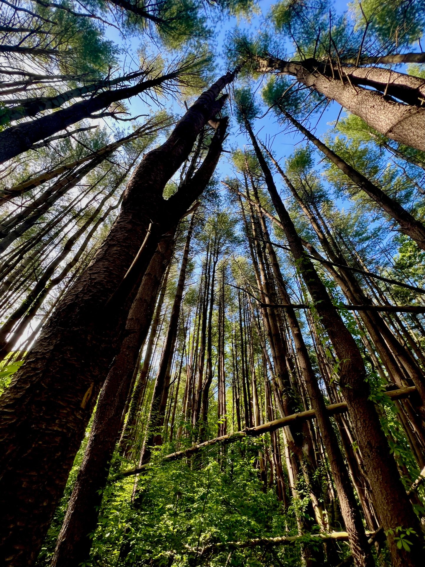
Photo by Bill Kutik
Something Special
But the preserve has an elegant grove of slender white pines, about 100 trees growing densely together, already about 80 feet high. Take the first right off the colonial highway and follow the White Trail marked by the sign “Elsie A. French Riding Trails.” Her brother Andre Beamount donated the first land for the preserve in 1968. She followed with donations in 1974 and 1979. The trees were probably planted about 80 years ago. Even on a slightly windy day, their tops sway magically in the breeze.
Our Recent History
This preserve is the foundation of Aspetuck Land Trust’s continuing multi-year effort to create the Weston Wilton Forest Reserve, a 705-acre protected forest, a generational opportunity to preserve the last forest of this size in our area. In 2021, we purchased two properties bordering and connecting like jigsaw puzzle pieces to the Bill Kutik Honey Hill Preserve: the 85-acre Daniel E. Offut Forest Reserve Gateway in Weston and 10 acres in Wilton which had approval to build two homes and turn the Old 2 Rod Highway into a driveway. Major funding from Westporter Bill Kutik helped block that development and the preserve was renamed to recognize him.

Bill Kutik
Photo by Nancy Moon
After being the founding editor of Backpacker magazine in 1972, Bill Kutik reported for the New York Daily News and The New York Times and edited two more magazines. He was already pursuing a second career when he moved to Westport in 1997: a self-employed analyst, columnist and impresario in the software industry for large organizations. He hiked the newly opened Trout Brook Valley. He was amazed not to be charged admission “as a National Park would for such a gem,” so he joined Aspetuck Land Trust and contributed larger and larger amounts – as he always said – in lieu of entry fees. Eventually he volunteered and later joined the board.
Where is it?
Wampum Hill Road
Weston, CT 06883
Directions & Parking
From the south: Take Georgetown Road (State Route 57) North, left on Cannondale Road, right on Wampum Hill Road. There is no parking at the preserve entrance where the pavement stops at the end of the road. Do not drive beyond the intersection with Honey Hill Road. The closest legal parking is on the left side of Wampum Hill Road (alongside the Belknap Preserve) before the intersection with Honey Hill Road. For more parking, turn left on Honey Hill Road and left on Mayapple Lane. Park at the end of the lane.
Aspetuck Land Trust has joined forces with the global community of citizen scientists through the iNaturalist app. You can now add your wildlife sightings to iNaturalist when you hike in the Bill Kutik Honey Hill Preserve. This helps us document and manage the property and is a great activity for kids!